Southern Tier Part 2 - Day #8 Cagle Recreation Area, TX to La Grange, TX
Southern Tier Part 2 - Day #8
April 20, 2022
Cagle Recreation Area, TX to La Grange, TX - 103 Miles
Start 7:37 AM Finish 9:07 PM
Ride Time 13:29
Ascent 5,189 Feet
Descent 5,154 Feet
Tour Total 703 Miles
Details at: https://ridewithgps.com/trips/87723254
I slept well at the Cagle Recreation campground at site number nine. Last night I had cooked macaroni and cheese and enjoyed ice cold bottles of Dos Equis at my picnic table. I went to bed early and had strange dreams. I was up before 7AM. There were birdwatchers wandering around the campsite while I was packing. I had run an extension cord into my tent and all my devices were charged by morning. There was no condensation in my tent. It was 70° F, and I decided not to wear a sweater or leg-warmers. I exited the campground and took a left on Highway 1375, which had medium motor traffic volume in both directions.
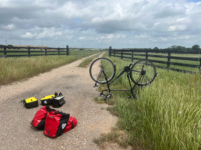
After four miles I could feel my front tire going soft. I had a flat. I walked back to a driveway to make the repair, which was a good move. The roadside grass was teaming with small biting insects. I couldn’t find the puncture and simply replaced the inner tube. It was a quick fix. The wind today was forecast to be out of the southwest. It seemed like it would be a crosswind and, fingers crossed, it might blow against my left hip. I came to a T and took a right onto Highway 149.
State Highway 149 had a nice four-foot wide shoulder. The white line had bumps added on top. I passed a field full of cattle and then a pasture with goats. There were horses on the other side of the highway. By 9 AM I had left the Samuel Houston National Forest. It was hazy and humid, and I was comfortable in my shorts. I reached a high point where I could see far in the distance. I was surrounded by cow pastures scattered with shade trees. Beyond that lay forest.
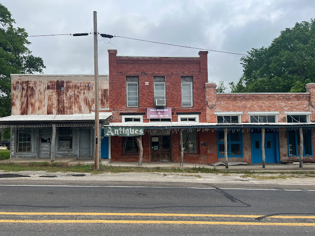
I passed Drifters Icehouse where there’s live music every Sunday from 1 to 5 PM. And then I crossed into Grimes County, which greeted me with a wide shoulder. I was on the Texas Forest Trail. I entered the town of Richards, no population listed, and then I crossed a railroad track. There was a guy out gardening his small plot with a pitchfork. I rolled into town and passed the boarded-up historic center. I noticed the community center, with a flag flying out front. The grocery store appeared to be open and there was a mannequin out in front of the fire house. I stopped at the general store for two egg sandwiches with bacon and cheese on biscuits, along with a Starbucks Frappuccino and a Tropicana 100% orange juice.
A week ago I was on a flight to New Orleans, and tomorrow I would ostensibly reach Austin, my halfway point in terms of mileage. I had adjusted to being out here. I was riding long stretches and the conditions had been favorable. I passed two east-bound male touring cyclists who didn’t stop to talk. They were enjoying their tailwind. There was a crosswind and I was riding in the shoulder. Motor traffic was light. I was concerned that a gust might blow me into the gravel.
Before breakfast I had seen my shadow for a moment. I had thought about putting on my sunglasses but never did. It was gray and overcast. I passed the intersection for Highway 2562. I met day cyclist Jutta who was out enjoying a ride. She mentioned that she was afraid of dogs, and was surprised that I hadn’t yet encountered any in Texas. She mentioned that she would like to do a cross country tour, but didn’t want to do one alone. She warned me that it would be hilly around Austin.
After a few miles I rode into Anderson, population 285. I came to intersection and joined State Highway 90 going southwest towards Navasota. Hopefully the shift in direction would give me an easier time with the wind. I passed the Knox Cafe, a Post Office, the First National Bank of Anderson, a Chevron, and an impressive municipal building. I was 10 miles from Navasota. On my way out of town I passed Yankee Doodle Donuts and a Dollar General, as well as the Anderson Car Wash. I was now on the Texas Brazos trail.
At 11 AM the sun appeared. I got a notification that my radar was low on battery. There must have been a bad connection last night. I crossed Holland Creek and then Spring Creek. The cross wind was intense which made it difficult to dictate. I pulled over and put on my sunglasses. I could see the white water tower from four miles away. Right before I got to Navasota I had another flat. It was once again my front tire. I found a small piece of blue glass in the tire, which I removed. I then replaced the tube. I entered Navasota, population 7049, and home of the Rattlers. I crossed under Highway 6 and rode by the Walmart. On my way into the center I noticed the Cow Talk Steakhouse.
I stopped at the Food Mart for a Coke. The clerk asked me where I was going and I replied La Grange. He told me that he used to live in La Grange. He complained that it was a small town and that he didn’t like it very much. I told him that I liked Navasota, and he said that he didn’t like Navasota either. He preferred College Station to the north, where Texas A&M University was located.
Map section 5 ended in Navasota and I pulled out map section 4, which would take me to Del Rio Texas. I was headed west on Highway 105 with a crosswind. I crossed the Navasota River and, after a couple of miles, crossed the Brazos River. There was an impressive railroad bridge to my right. I passed the God’s Country Cowboy Church, and at some point crossed into Washington County. I never saw a sign.
I took a right on William Penn Road which had a northwest heading. Hopefully I would benefit from a tailwind. Dictation was a disaster today because of the wind. My rear tail light and radar died so I stuck them in my handlebar bag to charge. I was on a small country road with no pavement markings or motor traffic. I passed a pasture full of cattle and noticed the Good Hope Cemetery. I was still seeing Spanish Moss.
In the town of William Penn I took a right on highway 390 and was again heading northwest. I had a moment of tail wind. I rolled into the town of Independence, no population listed, and crossed State Highway 50. I was parched for something cold to drink and noticed the General store, located in a beautiful old building. I purchased a Coke, a bag of hot peanuts, and couldn’t resist a giant pickle from the large jar at the checkout.
I battled the strong wind and crossed busy Highway 36. I rode into Gay Hill, no population listed. I passed the intersection with Highway 2679 and the town of Longpoint. There were no services. It was 4:17 PM in the afternoon and I had seventeen miles to the first possible camping spot, and thirty miles to the second. I was tired from battling the wind.
Highway 390 joined up with Highway 1948 for a spell, and then split off to continue west to Burton. I could see the white water tower from a few miles away, and eventually entered Burton, population 300. I stopped at Burton Short Stop for a Pepsi and bag of cashews. The place was packed with good ol’ boys drinking beer. Cheeseburgers were on the grill. My legs were spent, and I hated to leave. I rolled out of town and crossed Indian Creek. The route put me on US Highway 290, a four-lane divided motorway with 75 mile-an-hour traffic. It was like being on a freeway.
After two miles I split west on Highway 237 towards Round Top. The road was two lanes of traffic with a small shoulder and little traffic. I entered Fayette county. Round Top was five miles ahead and La Grange was 21. I noticed that it was supposed to be even windier tomorrow. La Grange had a much larger population and a better chance of scoring a big dinner. I was exhausted and decided to push on for better dinner options. I passed loads of outdoor antique dealers and lawn decoration places before coming to the town of Round Top, population 90. It was 6:15 PM and I still had sixteen miles to my destination. The antique places continued all the way into the center of town. Round Top seemed like a fun weekend destination. In addition to the antiquing, there were restaurants and breweries.
I rode through the towns of Warrenton, Oldenburg, and Rutersville. There were no populations listed for any of these. I noticed half a dozen large crows chomping away on a road kill deer. It was the first deer, dead or alive, that I’d noticed on this tour. I crossed under four lane State Highway 71 and entered La Grange, population 4,641. I was at 101 miles and was starving. I began searching for places to eat, and went to Las Fuentes where I enjoyed several margaritas. I ordered enchiladas Texanas with chicken, along with a few Dos Equis. After dinner I rode over to the RV park in the dark.


Comments
Post a Comment