Southern Tier Part 2 - Day #18 Esperanza, TX to El Paso, TX
April 30, 2022
Esperanza, TX to El Paso, TX 86 Miles
Start 7:13 AM Finish 5:47 PM
Ride Time 10:34
Ascent 1,450 Feet
Descent 1,187 Feet
Tour Total Miles 1536
Details at: https://ridewithgps.com/trips/88700251
What a night behind the Traveling Tiger Center Texas 87 Truck Stop. It made sense on paper, being that it was halfway between Van Horn and El Paso. Another option would have been a hotel twenty miles further into yesterday's headwind. Yesterday after I arrived, I was able to sit at a table at the back of the store for hours while I recharged my devices and caught up on work. When it got dark, I set up my tent out back. There was enough space for two hundred trucks in the lot, but there were only thirty. The truck stop was noisy. While setting up my tent I got pricked by a goat head that tore its way into my finger. A car alarm was intermittently going off. Trucks were pulling in and out. People were pumping gas. Horns were honking. Dogs were barking. I was exhausted and thought that I’d be able to fall asleep. Exasperated, I finally realized that I had to do something or I would never get any sleep. Fortunately I had packed Ambien tablets. In addition, I put in my earplugs, which slightly muffled the sound. Then I smothered my top facing ear with my clothes bag. I eventually fell asleep, and when I woke up it was light.
It was cool when I got up and the first thing I did was to retrieve my sweater. I was careful for goat heads while packing. There was a large cage behind the truck stop with a tire hanging inside and a wooden ramp. I think there used to be a wild animal inside. I Googled the truck stop and was only able to find a truck stop in Louisiana that kept wild animals. The Traveling Tiger Center Texas 87 Truck Stop has definitely seen better days.
I rode out of the parking lot and headed south on Highway 34. The noise from the Interstate and trucks subsided as I pedaled away. There weren’t any barbed wire fences along the highway and perhaps I should have stealth camped. Last night when I got up to get my ear plugs, I noticed brilliant stars in the sky. They would have been magnificent out in the desert. But there were definitely goat heads and Border Patrol, and I didn't want any issues. It was a beautiful morning. In addition to the usual, I was wearing leg-warmers and my sweater. My core was a little chilly but I resisted putting on my jacket. It was 72° F.
It was a beautiful morning riding south down Highway 34. The traffic volume was light. I took a right on Highway 192 through cattle grazing land and alfalfa grass. A friendly white dog greeted me from the left. I noticed a canal with drainage gates. The fields were criss-crossed with irrigation ditches. A large impressive mountain range stood to the west. I was traveling northwest and the wind was at my back. According to the wind forecast I would have a tail wind all day. I passed a sheep farm on my right.
A passed a large reservoir on my right and the earthen berm seemed recent. A road runner sped across the road. A Border Patrol passed me going east. I was less than half a mile from the border. Highway 192, a.k.a. Farm market Road, came to an intersection with Highway 20 and I took a left. I rode into McNary, no population listed, and noticed a silver lollipop water tower. I was riding alongside a railroad track and Highway 10 was visible to my right.
A passed a sign that read ‘Fort Hancock 4 miles, El Paso 56 miles’. The traffic on State Highway 20 was light to medium volume. I could clearly see the rusted border wall about a half mile to my left. A large mountain range stood behind it. I had about four inches of shoulder before the gravel and I had to ride to the left of the white line and pay close attention. I came to the junction of Farm Road 1088 and saw the US border patrol for Fort Hancock Station. It was a port of entry, and was ostensibly possible to enter Mexico. I didn’t see any traffic, and was passed by another Border Patrol going westbound.
I rode into Fort Hancock, population 2057, and took a right on 148 towards the Interstate to find something to eat. I was delighted to find Angie’s Restaurant, a.k.a. the Cowboy Cafe where I ordered huevos rancheros with orange juice. There were two large tables inside. At one, locals were speaking English, and the other they were speaking Spanish. I was at the Spanish speaking table. An older man was talking to younger guys about horses and cows. The English speaking guys were talking about the same thing. It took forever for the food to arrive, but it was worth the wait. I removed my sweater and leg-warmers and lathered myself with sunscreen before heading back south to the route. I passed a flag blowing and the wind was definitely out of the east. I would be enjoying a tailwind on my last day.
I returned to Highway 20 and took a right heading west. The border wall was to my left and Interstate 10 was to my right. Recently plowed fields sat to both sides of the highway. There was no shoulder with big chunky rocks to the side and a bumpy white line. I came to a sign that read ‘Acala 4 miles, El Paso 51 miles’. For some reason my phone and GPS were stuck in Central time. I had more time than I needed today. A motorist approaching in a sports car from behind started honking even before my radar picked him up. I was riding as close to the edge as I possibly could and he kept blasting his horn, even as he passed. I gave him the finger and hope he smashes his Porsche into a telephone pole. Drive on the Interstate if you want to go fast dude, or get the county to create a shoulder.
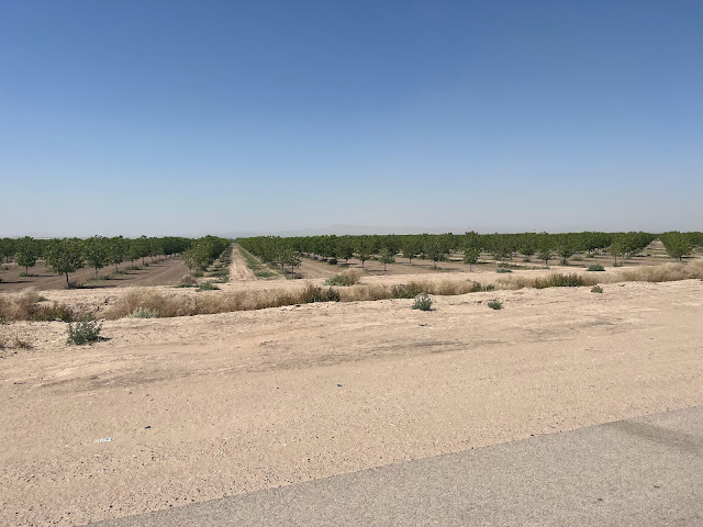
I rode through Alcala, no population listed. There were no services, and the Alcala grocery had long been shuttered. A large bug flew into my mouth and I was able to spit it out. You have to be quick with these things. I noticed a large reservoir to the left of the highway, and beyond that was a Rio Grande. I could see the border wall to the southwest. And then I began riding by orchards of perfectly spaced pecan trees. A truck with a trailer-full of alfalfa hay drove by, and I got a nice herbal whiff.
Today’s lovely ride through the Rio Grande Valley with a tailwind and very little motor traffic made up for yesterday’s harrowing experience on Interstate 10. There were now pecan groves to both sides of the road. Several different roads branched down to the Mexican border. I kept seeing Border Patrols, and trucks hauling bricks of alfalfa grass continued to pass me.
I rode through Fabens, population 8257. I noticed a silver water tower and a trailer park. An eastbound freight train came through. The conductor saw me signaling, but wouldn’t honk the horn. I stopped at 7-Eleven for a Coke and a blueberry muffin. Afterwards I headed north on Highway 76 going west. I rode by Clint, population 926, and Socorro, population 32,013. I was still passing irrigated fields but the suburban track housing was beginning. There was considerably more traffic. I got honked at while trying to cross the road to photograph a cell phone tower disguised as a palm tree. The shoulder was three feet wide and often traffic would be cautious when passing me I was still riding by groves of pecan trees. There were silhouettes of large mountains to the west.
And then Highway 76 turned into four lanes of divided traffic. I passed gas stations, auto parts stores, pharmacies, and car washes. I left Socorro and entered El Paso, population 620,456. I crossed under the ginormous Highway 375 loop and noticed a huge freeway network to the east. There was now a bike lane painted on the highway, which was nice. I passed the enormous De Valley Middle School on my left.
I had time on my hands and decided to visit a few breweries. The first was Blazing Tree Brewery, where I enjoyed a few Pecan Porters. It was 84° F when I left, and I still had another hour of riding to get to the hotel. I continued on busy Highway 76 pedaling through the sprawl and into the center of El Paso. There were enormous mountains to the west which I’ll be climbing in a few weeks when I begin the great divide.
I passed El Paso Community College Valle Verde campus, and then took a left and went up over a set of train tracks. I remained on highway 76 West. I passed a giant red X-shaped monument known as La Equis (The X), which symbolizes the blood spilled from the brutal Juárez drug wars. I rode right alongside the border and could see Mexican flags. It was weird to be so close to Mexico, where I had enjoyed such a great tour in January.
I stopped at the Old Sheepdog brewery where I relished two pints of Red Velvet with raspberries. The bartender mentioned that he had bike toured in Europe. He handed me a pop tart and a mazapán.
I rode over to my hotel and took a nice long bath. For dinner I pedaled into the center of town to Taft Diaz, where I enjoyed the Tuna Mahi, a Caesar salad, and Steak au poivre. Southern Tier Part 2 was now complete.
 |
| Possibly the worst place I've ever slept |
 |
| Traveling Tiger Center Texas 87 Truck Stop |
 |
| Speeding away from the truck stop |
 |
| West texas |
 |
| Alfalfa grass |
 |
| Bee hives |
 |
| Irrigation canal |
 |
| Pecan trees |
 |
| Pecan orchard with the border wall in the background |
 |
| Freight Train |
 |
| Cell Tower disguised as a Palm Tree |
 |
| Blazing Tree Brewery |
 |
| US Mexican Border at El Paso - Ciudad Juárez |
 |
| El Paso |
 |
| Old Sheepdog Brewery |
 |
| Motorists! Stay out of the bike lane! |
 |
| Southern Tier Part 2 Endpoint |
 |
| Map & Elevation Profile ⥢ prev -home- next ⥤ |


Comments
Post a Comment