Southern Tier Part 2 - Day #17 Van Horn, TX to Esperanza, TX
Southern Tier Part 2 - Day #17
April 29, 2022
Van Horn, TX to Esperanza, TX 54 Miles
Start 9:01 AM Central Finish 3:05 PM Mountain
Ride Time 7:06
Ascent 1,425 Feet
Descent 1,834 Feet
Tour Total Miles 1451
Details at: https://ridewithgps.com/trips/88562169
I slept great last night at the Sands Hotel in room number eleven. I was able to catch up on some work and finish an incomplete report. I could hear the murmur from I-10 and there was a ginormous truck stop next to the hotel. The train track was directly behind the hotel, and the building shook every time a freight train went through. I was fully rested in the morning and felt no pressure to get an early start because I would gain an extra hour today with the mountain time zone change. I cleaned and lubricated my chain before I left.
It was 70° F and sunny at 9 AM when I departed. I was wearing cycling shorts, short-sleeve jersey, arm protectors, and socks. I rode back to the center of town, past the El Capitan hotel, and got back on the route. I was on westbound business Loop 10 and was on the Texas Mountain Trail. The wind was strong out of the west and I knew it was going to be one of those days. The Guadalupe Mountains to the north were stunning.
On my way out of town I stopped at Porters Grocery Store for a Starbucks Frappuccino, a Tropicana no pulp 100% Orange Juice, and a Clover Hill danish with cheese. Sitting on the curb eating my breakfast I could see a flag wildly blowing in the wind. I didn’t need to look at the wind forecast but I did anyway. I was going to be fighting a strong headwind the entire day. I rode onto I-10 and was listening to a WFMU $mall ¢hange episode.
I was in the most mountainous part of Texas and there were gorgeous formations to the west and to the north. The train track was immediately to the right of the Interstate. I saw a sign for Sierra Blanca 31 miles and El Paso 119 miles. I crossed over Carrizo Creek and noticed a pedestrian walking along the shoulder. I then passed into Hudspeth County and entered Mountain time.
There’s nothing like riding a bicycle on an interstate with 80 mile-an-hour traffic while headed up hill into a headwind. I finally got to the top of the ridge and had to pedal down the other side because of the wind. I took the Interstate exit 129 for Allamoore and got on the frontage road. The frontage road ran alongside the Interstate and was much more comfortable and safer. The roar of motor traffic wasn’t as deafening, but the wind was still roaring. I was unable to hear the music on my iPod so I plugged into my iPhone where I could crank up the volume.
The strong wind was blowing around my rear view mirror. These mirrors are cheap and don’t last long in strong wind. I was nine miles from Sierra Blanca. My radar was going chirping crazy from all the westbound Interstate traffic. I was pedaling full force for seven to eight miles an hour. I could see Sierra Blanca from four miles away.
As I rode into town the frontage road became US 10 Business Loop. The railroad track was still immediately to my right. There were large ridges to both the south and north. Sierra Blanca has a population of 658. I noticed the West Texas Detention Center to my left and a train line from the southeast converged into the line I had been following.
A freight train passed me going west on the tracks that I had been riding alongside. A sign welcomed me to vaquero country (cowboy country). The second transcontinental railroad was completed here in 1881.
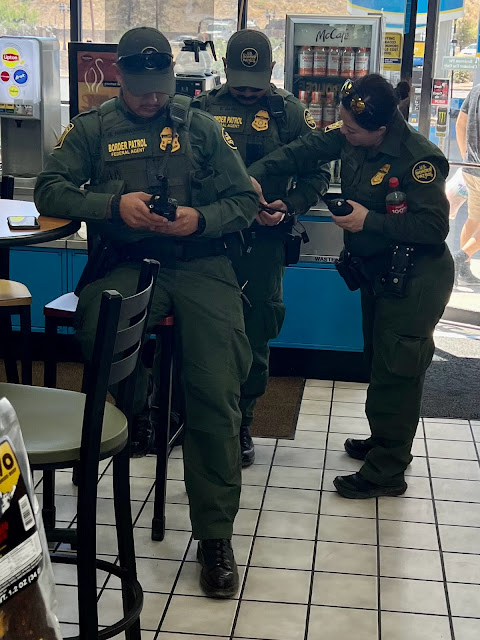
The Small Town Grill and the Best Cafe were both shuttered. Google let me down once again! Sierra Blanca has seen better days. I had to turn around and go back to the Valero station for lunch. Fortunately the Vaquero Grill inside was cooking meals to order. I got a cheeseburger with fries and a Pepsi. There were numerous Border Patrol agents inside ordering food.
After lunch I was back on the frontage road alongside the Interstate heading west. I passed a border patrol station in the eastbound lane of I-10 and 6890’ Sierra Blanca was to my right. The Interstate and frontage road bent around the Quitman Mountain range. I came to Lasca Road and went under the Interstate. I was now on a frontage road on the south side of the Interstate and still continuing west. Because I was riding against the nearby Interstate traffic my radar was less chirpy. After the elbow the Interstate and frontage road were heading southwest, and the wind wasn’t as bad. I could now do eleven to twelve miles an hour.
I came to the top of the ridge and a wide valley opened up before me, with large mountains to the west. The wind was still strong and I had to pedal to get down the hill. I knew that the frontage road would eventually end, and that I would end up back on the Interstate. I missed the gap in the median where I could cross to the westbound side. I rode on the eastbound shoulder, which was harrowing. I remember doing this with Scott and Eileen on the TransAm in Wyoming. I turned on my headlight for safety. I finally arrived at the exit for State Highway 34. There was camping available behind the truck stop. Unfortunately the restaurant was closed and the store selection was limited. This place has seen better days. I sat at a table in the back and edited this report while my devices charged.
 |
| Sands Hotel Room #11 |
 |
| Riding west out of Van Horn |
 |
| Riding west out of Van Horn |
 |
| I-10 Westbound shoulder |
 |
| Mountain Time |
 |
| Riding west on I-10 |
 |
| Riding west on I-10 |
 |
| Border Patrol Agents |
 |
| Sierra Blanca |
 |
| Border Patrol on I-10 East |
 |
| Surveillance System on I-10 West |
 |
| Strong Wind Currents |
 |
| West on I-10 |
 |
| Graffiti Rocks |
 |
| Riding west on the eastbound shoulder of I-10 |
 |
| Map & Elevation Profile ⥢ prev -home- next ⥤ |


Comments
Post a Comment